Pain and pleasure – 176 kilometres and 3.900 metres of altitude difference in two days.
As always: You choose your starting point yourself – the way it suits you best. You are also completely free to pick the date of your trip during the season.
Stages for your silver tour (2 days) on the Stoneman Arduenna
Tag 1
Etappe
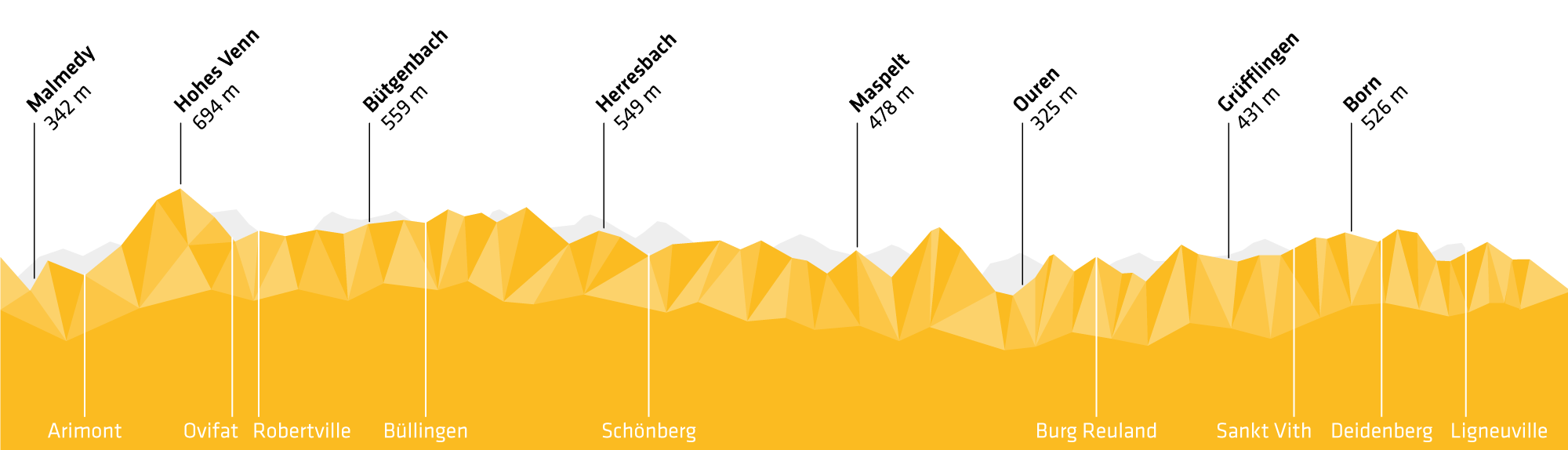
Bütgenbach » Sankt Vith
- 105 km
- 2.400 Hm
-
-
Checkpoints:
- Herresbach
- Maspelt
- Ouren
- Grüfflingen
Tag 2
Etappe
Sankt Vith » Bütgenbach
- 71 km
- 1.500 Hm
-
-
Checkpoints:
- Born
- Malmedy
- Hohes Venn
- Bütgenbach
Tag 1
Etappe
Schönberg » Ligneuville
- 96 km
- 2.400 Hm
-
-
Checkpoints:
- Maspelt
- Ouren
- Grüfflingen
- Born
Tag 2
Etappe
Ligneuville » Schönberg
- 80 km
- 1.500 Hm
-
-
Checkpoints:
- Malmedy
- Hohes Venn
- Bütgenbach
- Herresbach
Tag 1
Etappe
Burg-Reuland » Bütgenbach
- 87 km
- 1.950 Hm
-
-
Checkpoints:
- Grüfflingen
- Born
- Malmedy
- Hohes Venn
- Bütgenbach
Tag 2
Etappe
Bütgenbach » Burg-Reuland
- 89 km
- 1.950 Hm
-
-
Checkpoints:
- Herresbach
- Maspelt
- Ouren
Tag 1
Etappe
Sankt Vith » Herresbach
- 97 km
- 1.900 Hm
-
-
Checkpoints:
- Born
- Malmedy
- Hohes Venn
- Bütgenbach
- Herresbach
Tag 2
Etappe
Herresbach » Sankt Vith
- 79 km
- 2.000 Hm
-
-
Checkpoints:
- Maspelt
- Ouren
- Grüfflingen
11 tips for your silver tour (2 days) on the Stoneman Arduenna
- The Stoneman Arduenna can be done in two days. Start at 9am at the latest, depending on your performance level and length of day. This way you have enough buffer for breaks – especially at the many highlights and attractions – or if something unforeseen should happen.
- Do you have everything you need overnight?
- Before you start, take a close look at the route map in your starter pack and read the stage descriptions. Memorize the hazard zones in particular!
- Check the weather forecast and bring appropriate clothing. Temperatures change between altitudes and the weather in the mountains can change quickly.
- To be on the safe side, load the latest GPS track onto your smartphone. That way you'll know – in case of doubt – whether you're still on the track.
- It's best to use an app for the GPS that can save maps offline. Maps.me and HereWeGo work fine.
- You will receive the latest GPS track with your starter pack reservation by e-mail three days prior to your start or on site at the official issuing offices and lodging partners.
- Take enough water and food with you. Be sure to refill your water reserves whenever possible. Maybe the next water station is temporarily unavailable.
- Take your time to read the information board at the checkpoints. That way you can relax, pause for a moment and prepare for the next stage.
- Bring a whistle if you're riding alone! Inform your official issuing office if you return later than planned or have to cancel. You will find the telephone number on the route map in your starter pack.
- In order to be available on the mobile phone network along the state borders, you should set your mobile phone accordingly.
Ready for Silver?